Usually when I haven't posted for a while, it's because I've been out of range, but this most recent gap is quite simply because I haven't been doing anything interesting.
I stayed at Wannamal for a couple of days and headed down to Perth and booked in to the Kenlon Caravan Park in Kewdale. It is a pretty scungy park but it is cheap which is what I want for any extended stay and it's convenient - close to shopping and Services with which I am familiar. I have a number of personal issues to sort out while I'm here so I booked in for 4 weeks which will take me up to just before Xmas.
What a year it has been. One year ago today (18th December) was when the rain started bucketing down in Queensland's South Burnett and stranded me over Christmas. Then down to Brisbane and the Brisbane/Toowoomba/Grantham floods which stranded me in Brisbane. Down through Tenterfield and Tamworth heading for Broken Hill and marks of flood damage everywhere. Close to Broken Hill and I couldn't move off the main highway, because all of the side roads to anywhere else were all either under water or badly flood-damaged.
Down to the Flinders Ranges and got there just after the floods - some of the gorges were still closed. By now it's April so up through Leigh Creek and I got flooded in at Farina, then had to go back to Leigh Creek and sit there until the Oodnadatta Track re-opened. No chance of doing the Strezlecki or Birdsville tracks, they're both under water. There was still plenty of water around and I was actually able to wade knee-deep in Lake Eyre, I can't see that happening again anytime soon. More rain near Oodnadatta, which made the road very boggy, but finally made it through to the bitumen at Marla and on to the Alice. By now it is May and I have done what I really didn't want to do - camp in the Red Centre in winter. Admittedly, it's better than winter down south, but boy! it can get cold and the wide-open spaces allow the chilly winds to get a good run-up.
Up the Tanami Track to Hall's Creek. The reports from the Gibb River Road weren't encouraging, but the chance to do it again was irresistible. To Derby and down to Broome in August and finally getting some good weather. Inland through Marble Bar to Newman and then across through Wittenoom to Karratha. Then down the coast to Carnarvon and inland to Gascoyne Junction which had been absolutely devastated in the floods at the beginning of the year. South to Murchison and Mullewa and so on to Perth, just over two years since I left.
In to the Doctor's to have a skin cancer cut out of my nose (got the lot, thank Ghu), new springs for the van (I had flattened the original ones so badly, the axle was sitting on the bumpers on the frame, In to the dentist to get my teeth fixed up (I lost a couple during the year and my plate won't stay in anymore) and here we are again, almost Xmas. I must admit, I have been going through one of my "can't be bothered" phases when I am content to just sit on my bum and read rather than getting out and about. Fancy that, having a "sickie" when you are retired????
To my family, my friends old and new, and to any who happen across the blog by accident - Merry Christmas and a Healthy and prosperous New Year to you and yours.
The year in review:
Totals so far, 1,101 days on the road and I have covered 58,251 kms since leaving Perth on 13 Dec 2008. This year, since Jan 1, I have travelled a bit over 11,800 kms which averages out to just under 34 kms per day. Now that's a nice sensible pace with plenty of time to smell the roses. This year, I think will be even more relaxed. I want to do the "Granite and Woodlands Way" from Hyden to Norseman again this year - the last time I tried it was thunderstorms all the way. In addition, I want to have a go at the Northern section of the Holland Track and the Cave Hill track from Coolgardie. Also I want to spend some time down on the south coast of WA and I haven't decided yet where I want to go for the winter when I head north again.
I am going to sit here in Perth until the New Year and refreshed and re-invigorated, head for the Great Southern for the start of summer.
See you in 2012.
Sunday, December 18, 2011
Sunday, November 13, 2011
The Murchison
I remember long ago reading Robert Frost's poem "The Road Not Taken", and in the second-last line he said that he "took the one less travelled by. . ." Well the inland road from Carnarvon to Mullewa via Gascoyne Junction and Murchison is certainly that.
The road heads roughly east from Carnarvon to Gascoyne Junction and then south through Murchison to Mullewa on the Geraldton - Mt. Magnet road. The road is bitumen all the way to GJ (173 kms) and then gravel all the way to Murchison (308 kms). From Murchison to Mullewa the first 50 kms is single lane bitumen, then 100 kms of gravel, and then the last 50 kms into Mullewa is dual-lane bitumen.
I took 17 days to travel the road and during that time, I saw exactly three other travellers using the road. There were a few other vehicles on the road, but these were obviously work or station vehicles. The road, especially in the Murchison shire, was excellent. Very few corrugations and a good, solid surface. You would have no trouble even in a conventional 2-wheel-drive car, provided there hadn't been any rain. There was evidence in several places where there had been some monumental boggings!
Tuesday, 25th October 2011 - Day 1,047
I left Carnarvon bright and early, heading for a campsite called Rocky Pool on the Gascoyne River. Well, there is a pool there and it is very rocky, but calling it a campsite is a bit of a stretch. I pulled up at the "spot", picnic table, barbecue and interpretive sign and then walked for at least a kilometre both up and down the river looking for a nice spot to set up camp. Nothing, not an even remotely suitable spot. It looks like a great picnic area, or a place to take the kids for a swim, but really not suitable for an overnight camp. It was still fairly early in the day, so I kept going.
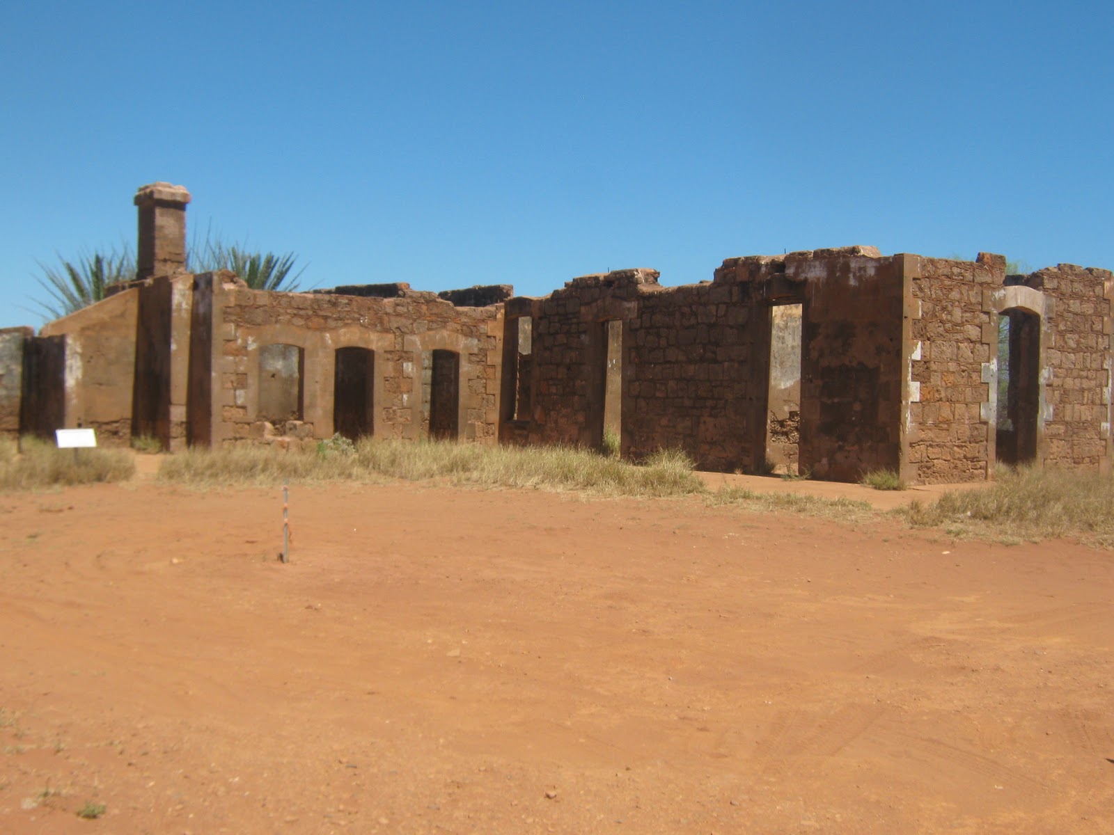
Just after lunch I arrived in (or it may be more appropriate to say "at") Gascoyne Junction. There were some pretty severe floods here earlier in the year following 11 inches of rain in one hit, and the hotel/caravan park/visitor's centre/roadhouse was washed away. All that remains is the forecourt of the roadhouse. I remember seeing on TV about Carnarvon being flooded, but nothing about this area. This is all that remains of the hotel.

The shire office, police station and the school are all on higher ground and were OK but the low-level areas were all washed away. There was an area called the "Hacker's Hectare" where the shire had placed blocks of stone for visiting amateur sculptor's to hack away at and I understood this was also a camping area. Nothing left, just a big expanse of bare dirt.
I continued on and about 70 kms down the road came to an area of what are termed "breakaways". There were several clear, flat areas at the base of the features so this looks the ideal place to stop for a few days.


Monday, 31st October 2011 - Day 1,053
What a great little spot for a bush camp. The rock formations are very interesting and the little hills are easily climbable so there is plenty of opportunity for exploring. There are some REALLY big old-man kangaroos around the area and when you come across one and it bounds away, it can scare the crap out of you.


The weather has been mostly fine, overcast for the first couple of days and then clear and sunny with a nice cool breeze, but yesterday it was very windy and blew up to gale force last night, nearly wrecked the awning before I got it down. Today there have been some really big thunderstorms around but, touch wood, they have mostly passed around to the south of me.


Tuesday, 1st November 2011 - Day 1,054
Well, my luck couldn't hold forever, today I had one thunderstorm pass to the west, then the next one passed to the east but the third one this afternoon copped me dead centre. It absolutely poured for about two hours, while still blowing very strongly, so the rain was almost parallel to the ground. I chose my campsite well, however, on a sandy rise between two obvious rain channels, so everything is cool.
Thursday 3rd November 2011 - Day 1,056
The worst of the weather seems to have passed, still lots of clouds around but no thunderstorms. A little rain overnight but only light. I actually had to dig out the generator and crank it up for the first time in months, because I haven't seen much of the sun for the last few days and the batteries are getting a bit low. The sound of the generator seems to have attracted some of the locals to check out what's going on.
One good thing about this kind of weather, you can get some magnificent sunsets.


According to the weather reports they have really been copping it down south, so I'm glad I made the decision to wait until November before heading for Perth. I went over to the main track and checked out the road for rain damage, but it looks fine, so I'll take off again tomorrow.
Friday 4th November 2011 - Day 1,057
I have a map-book of WA 4WD tracks and it showed a spot called Bilung Pool on the Wooramel River about 150 kms north of Murchison, which wasn't on the HEMA maps or in the Camps book, and as it was only a couple of kmsfloodways, ant nests and other nasty surprises. Just as well I did. What appears to be a nice, shady, level area right next to the pool, is a really big over-hang which doesn't look all that stable from below. It may have collapsed even by just driving on it. Could have been a disaster. How is this for a view out of the kitchen window?


Sunday 6th November 2011 - Day 1,059
The weather has come good again, not a cloud in the sky and about 28degC during the day and 15 at night. A few pesky bush flies around, but not too bad. I went for a wander along the river and some really interesting rock formations gouged out by the river during flood times. I found a lot of spots where people have been camping and it looks like this might be a popular fishing spot when there is water in the river.


Monday, 7th November 2011 - Day 1,060
I packed up this morning and continued south to Murchison. It would appear that there has been some serious flooding through here recently as well. About 50 kms north of Murchison, there is a 15 km detour along station tracks while the main track is being repaired and a little further on, there was another 12 km detour, but the main road has just been re-opened. Definitely not the place to be when it floods.
It appears that this road is an old stock route from the midlands to the Ashburton. In addition, it is part of what is called the "wool-wagon pathway" and also part of the Kingsford-Smith Mail Run. There are a number of interpretive sites all along the track. Below is the remains of one of the original stock route wells which has been restored.

 I can't get over how good this road is. If I was in a hurry, I would have no hesitation in driving at 100kmh or more. No corrugations, good drainage, good camber on the bends, I have driven on bitumen which was a lot worse than this. Even the locals use the road.

I got to Murchison and stopped at the roadhouse to see if they had any fresh milk. Not to be, only UHT, which I hate. I thought I would check out the fuel price and nearly fell down with my leg in the air! $1.52 per litre for diesel. That is cheaper than it was in Carnarvon, so I filled up. I have been carting 60 litres in jerry cans for nothing it seems. I would have thought that in a place as remote as this, that fuel would be up around $1.80 or more, but it appears that fuel prices are subsidised by the shire council. Passing strange, methinks.
Again, my WA 4wd tracks book shows a feature 12kms west of Murchison, called Errabiddy Bluff, which is not on the HEMA map so after fuelling up and buying a frozen loaf of bread for $4.50 I headed out. It is obviously a station track, but it had been recently graded although a bit sandy in places but on the whole a good road.
On the way to the bluff are the remains of an old out-station building from Errabiddy station which was in use from the 1920's. Stone with mud mortar and the chimney is still standing, albeit with a bit of a lean and you can still see the outline of the walls. I think it would be really interesting to excavate a site like this and I wonder why archaeologists aren't interested. Maybe Time Team would be. I particularly like the old bush dunny which has either been restored or re-created.


A few kms further on is the bluff and very impressive it is too. The block-like nature of the stone at the top makes it look as though it was actually built by hand. It reminded me of the stone buildings of Machu Pichu. Looks like some extreme bush-walking coming up.

Tuesday, 8th November 2011 - Day 1,061
Oh boy, the Penguin is falling to pieces. I noticed that the rear of the roof seemed a bit hard to get down when I packed up yesterday, but I didn't think anything was wrong. When I came to set up last night, I found that the roof bolt on the RH rear strut has sheered and on top of that, as I was winding up the roof, the LH front cable gave way (third time for this same cable). I had to jack the roof up and hold it up using tent poles. This morning I emptied out the front storage area under the bed and checked out the cable. Luckily, the cable had not snapped, it had just pulled out of the cable clamps which had loosened from vibration, so it was fairly simple to fix. The rear roof-bolt has definitely sheered, though and as I don't have a spare, that will have to wait until I can get a replacement from a hardware store. This is the second time that a roof-bolt has sheered (see Tennant Creek, day 588) so I think I will remove them all and replace them with high-tensile bolts.
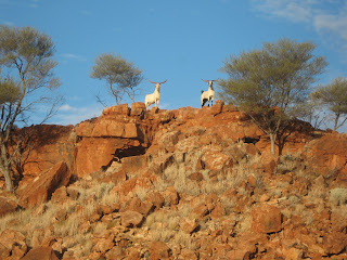
I went for a walk and climbed up to the top of the bluff for a bit of a look around. What a view! If you look really, really closely, you can see my van in the centre of the photo below. Lots and lots and lots of feral goat's nests up on top of the bluff, but no sign of goats, they must have all been at work.

Sunday, 13th November 2011 - Day 1,066
I only stayed for three days at the bluff, I am running low on some basics like spuds and onions and I am out of milk and bread (although I have some evaporated Carnation milk for my coffee) so I packed up and headed for Mullewa. As I said above, the first 50 kms south of Murchison were single-lane bitumen which was a pleasant surprise. Probably because of frequent flooding, this part of the road parallels the Murchison River. But even when I ran out of bitumen, the road was excellent. I stopped for a breather where the road crosses the Murchison River and there were a couple of nice spots suitable for a bush camp along the river bank.

I made it into Mullewa and re-stocked with essentials, but boy, do they know how to charge - $4.75 for 2 litres of milk and $3.80 for a 650gram loaf of bread.
I headed out of Mullewa towards Geraldton to stop at a spot I camped at just over two years ago, a location called Tenindewa. (day 304 12Oct09). I found it OK and set up. Important note to self: when you are returning to a spot previously visited, read up the notes from before. If I had, I would have remembered that this spot has the worst bush flies in Oz. I assume that the ones that were here before have all passed on, but their grand-children have been fruitful and multiplied. There are HORDES of them. Also, I couldn't camp in the really nice spot that I picked last time, because a colony of bees has set up house in the hollow tree stump where I parked. Jeez, I'm such a whinger.
I will make one more stop before I get to Perth. I found a nice spot in Wannamal last trip, so I'll camp there for a couple of nights and then head to Perth.
See you soon.
The road heads roughly east from Carnarvon to Gascoyne Junction and then south through Murchison to Mullewa on the Geraldton - Mt. Magnet road. The road is bitumen all the way to GJ (173 kms) and then gravel all the way to Murchison (308 kms). From Murchison to Mullewa the first 50 kms is single lane bitumen, then 100 kms of gravel, and then the last 50 kms into Mullewa is dual-lane bitumen.
I took 17 days to travel the road and during that time, I saw exactly three other travellers using the road. There were a few other vehicles on the road, but these were obviously work or station vehicles. The road, especially in the Murchison shire, was excellent. Very few corrugations and a good, solid surface. You would have no trouble even in a conventional 2-wheel-drive car, provided there hadn't been any rain. There was evidence in several places where there had been some monumental boggings!
Tuesday, 25th October 2011 - Day 1,047
I left Carnarvon bright and early, heading for a campsite called Rocky Pool on the Gascoyne River. Well, there is a pool there and it is very rocky, but calling it a campsite is a bit of a stretch. I pulled up at the "spot", picnic table, barbecue and interpretive sign and then walked for at least a kilometre both up and down the river looking for a nice spot to set up camp. Nothing, not an even remotely suitable spot. It looks like a great picnic area, or a place to take the kids for a swim, but really not suitable for an overnight camp. It was still fairly early in the day, so I kept going.
Just after lunch I arrived in (or it may be more appropriate to say "at") Gascoyne Junction. There were some pretty severe floods here earlier in the year following 11 inches of rain in one hit, and the hotel/caravan park/visitor's centre/roadhouse was washed away. All that remains is the forecourt of the roadhouse. I remember seeing on TV about Carnarvon being flooded, but nothing about this area. This is all that remains of the hotel.

The shire office, police station and the school are all on higher ground and were OK but the low-level areas were all washed away. There was an area called the "Hacker's Hectare" where the shire had placed blocks of stone for visiting amateur sculptor's to hack away at and I understood this was also a camping area. Nothing left, just a big expanse of bare dirt.
I continued on and about 70 kms down the road came to an area of what are termed "breakaways". There were several clear, flat areas at the base of the features so this looks the ideal place to stop for a few days.


Monday, 31st October 2011 - Day 1,053
What a great little spot for a bush camp. The rock formations are very interesting and the little hills are easily climbable so there is plenty of opportunity for exploring. There are some REALLY big old-man kangaroos around the area and when you come across one and it bounds away, it can scare the crap out of you.


The weather has been mostly fine, overcast for the first couple of days and then clear and sunny with a nice cool breeze, but yesterday it was very windy and blew up to gale force last night, nearly wrecked the awning before I got it down. Today there have been some really big thunderstorms around but, touch wood, they have mostly passed around to the south of me.


Tuesday, 1st November 2011 - Day 1,054
Well, my luck couldn't hold forever, today I had one thunderstorm pass to the west, then the next one passed to the east but the third one this afternoon copped me dead centre. It absolutely poured for about two hours, while still blowing very strongly, so the rain was almost parallel to the ground. I chose my campsite well, however, on a sandy rise between two obvious rain channels, so everything is cool.
Thursday 3rd November 2011 - Day 1,056
The worst of the weather seems to have passed, still lots of clouds around but no thunderstorms. A little rain overnight but only light. I actually had to dig out the generator and crank it up for the first time in months, because I haven't seen much of the sun for the last few days and the batteries are getting a bit low. The sound of the generator seems to have attracted some of the locals to check out what's going on.

One good thing about this kind of weather, you can get some magnificent sunsets.


According to the weather reports they have really been copping it down south, so I'm glad I made the decision to wait until November before heading for Perth. I went over to the main track and checked out the road for rain damage, but it looks fine, so I'll take off again tomorrow.
Friday 4th November 2011 - Day 1,057
I have a map-book of WA 4WD tracks and it showed a spot called Bilung Pool on the Wooramel River about 150 kms north of Murchison, which wasn't on the HEMA maps or in the Camps book, and as it was only a couple of kmsfloodways, ant nests and other nasty surprises. Just as well I did. What appears to be a nice, shady, level area right next to the pool, is a really big over-hang which doesn't look all that stable from below. It may have collapsed even by just driving on it. Could have been a disaster. How is this for a view out of the kitchen window?


Sunday 6th November 2011 - Day 1,059
The weather has come good again, not a cloud in the sky and about 28degC during the day and 15 at night. A few pesky bush flies around, but not too bad. I went for a wander along the river and some really interesting rock formations gouged out by the river during flood times. I found a lot of spots where people have been camping and it looks like this might be a popular fishing spot when there is water in the river.


Monday, 7th November 2011 - Day 1,060
I packed up this morning and continued south to Murchison. It would appear that there has been some serious flooding through here recently as well. About 50 kms north of Murchison, there is a 15 km detour along station tracks while the main track is being repaired and a little further on, there was another 12 km detour, but the main road has just been re-opened. Definitely not the place to be when it floods.
It appears that this road is an old stock route from the midlands to the Ashburton. In addition, it is part of what is called the "wool-wagon pathway" and also part of the Kingsford-Smith Mail Run. There are a number of interpretive sites all along the track. Below is the remains of one of the original stock route wells which has been restored.


I got to Murchison and stopped at the roadhouse to see if they had any fresh milk. Not to be, only UHT, which I hate. I thought I would check out the fuel price and nearly fell down with my leg in the air! $1.52 per litre for diesel. That is cheaper than it was in Carnarvon, so I filled up. I have been carting 60 litres in jerry cans for nothing it seems. I would have thought that in a place as remote as this, that fuel would be up around $1.80 or more, but it appears that fuel prices are subsidised by the shire council. Passing strange, methinks.
Again, my WA 4wd tracks book shows a feature 12kms west of Murchison, called Errabiddy Bluff, which is not on the HEMA map so after fuelling up and buying a frozen loaf of bread for $4.50 I headed out. It is obviously a station track, but it had been recently graded although a bit sandy in places but on the whole a good road.
On the way to the bluff are the remains of an old out-station building from Errabiddy station which was in use from the 1920's. Stone with mud mortar and the chimney is still standing, albeit with a bit of a lean and you can still see the outline of the walls. I think it would be really interesting to excavate a site like this and I wonder why archaeologists aren't interested. Maybe Time Team would be. I particularly like the old bush dunny which has either been restored or re-created.


A few kms further on is the bluff and very impressive it is too. The block-like nature of the stone at the top makes it look as though it was actually built by hand. It reminded me of the stone buildings of Machu Pichu. Looks like some extreme bush-walking coming up.

Tuesday, 8th November 2011 - Day 1,061
Oh boy, the Penguin is falling to pieces. I noticed that the rear of the roof seemed a bit hard to get down when I packed up yesterday, but I didn't think anything was wrong. When I came to set up last night, I found that the roof bolt on the RH rear strut has sheered and on top of that, as I was winding up the roof, the LH front cable gave way (third time for this same cable). I had to jack the roof up and hold it up using tent poles. This morning I emptied out the front storage area under the bed and checked out the cable. Luckily, the cable had not snapped, it had just pulled out of the cable clamps which had loosened from vibration, so it was fairly simple to fix. The rear roof-bolt has definitely sheered, though and as I don't have a spare, that will have to wait until I can get a replacement from a hardware store. This is the second time that a roof-bolt has sheered (see Tennant Creek, day 588) so I think I will remove them all and replace them with high-tensile bolts.
I went for a walk and climbed up to the top of the bluff for a bit of a look around. What a view! If you look really, really closely, you can see my van in the centre of the photo below. Lots and lots and lots of feral goat's nests up on top of the bluff, but no sign of goats, they must have all been at work.

Sunday, 13th November 2011 - Day 1,066
I only stayed for three days at the bluff, I am running low on some basics like spuds and onions and I am out of milk and bread (although I have some evaporated Carnation milk for my coffee) so I packed up and headed for Mullewa. As I said above, the first 50 kms south of Murchison were single-lane bitumen which was a pleasant surprise. Probably because of frequent flooding, this part of the road parallels the Murchison River. But even when I ran out of bitumen, the road was excellent. I stopped for a breather where the road crosses the Murchison River and there were a couple of nice spots suitable for a bush camp along the river bank.

I made it into Mullewa and re-stocked with essentials, but boy, do they know how to charge - $4.75 for 2 litres of milk and $3.80 for a 650gram loaf of bread.
I headed out of Mullewa towards Geraldton to stop at a spot I camped at just over two years ago, a location called Tenindewa. (day 304 12Oct09). I found it OK and set up. Important note to self: when you are returning to a spot previously visited, read up the notes from before. If I had, I would have remembered that this spot has the worst bush flies in Oz. I assume that the ones that were here before have all passed on, but their grand-children have been fruitful and multiplied. There are HORDES of them. Also, I couldn't camp in the really nice spot that I picked last time, because a colony of bees has set up house in the hollow tree stump where I parked. Jeez, I'm such a whinger.
I will make one more stop before I get to Perth. I found a nice spot in Wannamal last trip, so I'll camp there for a couple of nights and then head to Perth.
See you soon.
Monday, October 24, 2011
The Outback Coast WA
I really stretched the limits with my stay at Robe River, I didn't leave until October 11th, but there were not all that many each night, so I wasn't preventing anybody else from staying.
Tuesday, 11th October 2011 - Day 1,033
I was heading south from Robe River and came to the turn-off to Onslow and decided to take the side-trip and check it out. I have been past numerous times but never managed to drop in. I'm glad I did, it is a very pleasant little town although that may change with the plans to build a major gas hub here, the pipes are already being laid so it won't be long now.

Onslow was rebuilt in a different location after a major cyclone blew the original town away back in 1925 and the Old Town is about 40 kms away, right at the mouth of the Ashburton River. There is a camping area at "Five Mile Pool", 8 kms (obviously) from Old Onslow and I checked it out when I went out to look at the ruins of the old town. It is a series of spots running for about 2 kms along the east bank of the river and is a fantastic spot although there are no facilities except rubbish bins. The local map says that you need a permit from the shire office in Onslow itself if you want to stay more than 3 days, so I popped in and got a permit (no charge) for a week. A really great spot as you can see.


There were some locals who dropped in for a feed each evening, but they didn't each much, cleaned up after themselves and left fairly early.

There is very little of the old town left except for the ruins of the old police station and jail and for the pioneer cemetary. Evidently most of the original buildings were either relocated to sheep staions as homestead buildings, or relocated to the new town (where they were all blown away in a major cyclone in the 1960's

Monday, 17th October 2011 - Day 1,039
I packed up and drove into Onslow and booked in to the caravan park for a couple of nights, mainly to get some washing done, I had completely run out of clean shorts and t-shirts. The ever-present red dust that I have been experiencing ever since leaving the Kimberley makes it very hard to get more than a single day out of a shirt or shorts. The caravan park is called Ocean View and that's true as far as it goes. The park fronts on a strip of ratty-looking sand about 3 metres wide which overlooks the mud flats. Not the most attractive spot I've ever seen.
You should all know by now that I am not one who usually complains, but can anyone tell me why every caravan park you go to, the shower heads are only about 5-foot from the floor? The average aussie male is at least 5' 10" or so and yet all the shower stalls seem to be built for midgets.
Monday, 24th October 2011 - Day 1,046
I stopped at the rest area at Lyndon River for a couple of days after leaving Onslow and then headed for Carnarvon. I was only going to stay for one night, but they had a special deal at the Wintersun Caravan Park. 3 nights for the price of 2, plus my Top Tourist discount plus they gave me a "single" rate because I'm on my own. $48 for three nights is cheap as chips after paying some of the inflated prices further north. Wintersun Carnarvon gets my seal of approval!
Well, I'm all fuelled up, the fridge, pantry and wine cellar are all re-stocked so I'm heading bush again. East to Gascoyne Junction and then south through Murchison (the only shire in Oz which doesn't have at town) to Mullewa. Probably be another month before I get back to civilization, so . .
See you soon
Friday, October 7, 2011
The Pilbara Coast
Photographs don't get much fresher than this, taken 30 seconds ago from my delightful campsite overlooking the Robe River while I update this blog.
 Gee, Life is tough! I wonder what the poor people are doing? Anyway, time to update you on my travels - Last time I posted I had just arrived in Newman and re-stocked with essentials.
Thursday, 8th September 2011 - Day 1,000 ! ! !
1,000 days! It's incredible to think that I have been on the road for this long and I am still not bored or jaded in any way. Every day is still an adventure and I still look forward to more time spent travelling. I will admit that since I made the decision to slow down and spend more time camping and less time driving, my "quality of life" has improved immesurably. Who ever it was who coined the phrase "take the time to smell the roses" (or whatever) really knew what they were talking about.
I pulled in to the Albert Tognolini Rest Area at Munjina Gorge, about 17 kms south of the Auski Roadhouse and this gets a guernsey in my top ten favourite campsites. The rest area itself is H-U-G-E with plenty of room to spread out without being right next to somebody else's screaming kids / yapping dogs / blaring music / noisy generator / phone calls (fill in your own pet hate here). Rather than simply a big camping area, there are several "island" sites spread all along the ridgeline and the scenery is simply stunning. I think I might be here for a while as there is great potential for some serious bushwalking.


Thursday, 15th September 2011 - Day 1,007
Still at Munjina Gorge, This place is fantastic. Make sure you put it in your "to-do" list. The weather has been fine, but very windy. It has been blowing an absolute gale ever since I got here, but it seems to be calming off a bit now. I don't know what the wind speeds actually were, but I had serious concerns for the Penguin, I really thought the awning was going to tear free from the van and it was way too windy to try and roll it up.
Went for a couple of wanders up the hills surrounding the gorge and also down into the gorge itself. I absolutely have to come back here when the wet season has filled the creeks, there are a couple of waterfalls which must be spectacular when the creeks are flowing.


Wednesday, 28th September 2011 - Day 1,020
No, that's not a misprint, I ended up staying at Munjina for 3 weeks (don't tell the ranger). To be fair, I was tucked away right at the far end of the area, probably about a kilometre from the "day" area, so I wasn't inconveniencing anybody by over-staying.
I finally packed up and headed north, bought some bread and milk at Auski and headed in to Wittenoom. The road is pretty rough, but the scenery is great. The road follows the edge of an escarpment so there are ridgelines to one side and a huge flat plain to the other. Wittenoom itself is even more run-down and deserted than when I was here several years ago. There are supposed to be 8 people still living here, but the gem shop and the campground both appear to be closed down. There are signs everywhere warning about the danger of asbestos, so I erred on the side of caution and didn't go into the gorge itself.


 Onwards to Tom Price - rough road and BLOODY dusty. Couldn't go into Hammersley Gorge, the road was closed, probably from damage during the last wet season - oh well, been there, done that before. The last 2 kms or so of the road before the Hammersley gorge turn-off, through a gorge, has been sealed, which was a relief, it was basically a sandy creek bed last time I was here about 8 years ago and I was a little worried about pulling the van through sand, but no wucker's.
Blew a tire on the van (on the bitumen, mind you) just short of Tom Price and had to buy a replacement. Pissed off to say the least - I only bought new tyres for the van in Broome. The problem with the van tyres, is that you can't feel any problem until the van starts bouncing all over the place and by that time the tyre is stuffed.
I headed for Millstream up the Tom Price Railway Access Road. I asked about a permit at the Information Centre and had to sit and view a 20 minute safety video. It was like being back at work again running inductions. The road wasn't too bad, I sat on 70 kph for most of the way (maximum speed limit of 80) but a lot of floodways on the road and some of them were pretty rough at the bottom of the dip, so averaged only about 50 kph with all the slowing down.
I got to the Millstream turn-off and the access road was absolutely awful. The road is very poorly maintained if at all. After 11 kms I got to the first campsite access, Crossing Pool. The fees posted were $11 entry to the park (one-off) and $8 per person per night for camping. The information board describing the camping areas was very un-inviting pointing out that most of the areas had very limited shade, un-treated water and no showering facilities. It was 10 kms to the campsite with a sign that said "rough road - 4WD only" or still another 11 kms of that rotten road to the visitor's centre, I decided that I wasn't all that impressed and decided to give it a miss. Maybe another time (or maybe not).
The bitumen from Karratha has been extended as far as the Python Pool turn-off, 100 kms from Karratha, so I stopped in a lay-by and re-inflated my tyres from the 26 psi I run on gravel and there, right at my feet was a gorgeous Sturt's Desert Pea. Obviously the season because they're everywhere.

Heading into Karratha, I spotted what to me is the quintessential Pilbara landscape. The hills are basically just pure ironstone, increadibly weathered and crumbling, with just a covering of desert spinifex.

I headed for the campsite at Miarree Pool, about 30 kms south of town, I have been looking forward to this ever since I left Tom Price. I got to the spot on the north bank of the river where I camped a couple of years ago and found a big (new) sign, saying "NO CAMPING - $1000 on-the-spot fine" What a bummer! this was a really nice spot to camp. I pulled out and headed down the highway and noticed several vans camped on the south side of the river so I pulled in and was advised that the ranger had been around and told everyone that they had to be out by Monday. I decided to try my luck as I really needed to re-stock before heading further south. Sure enough, the ranger came around on Saturday afternoon and, while he was quite polite and pleasant, said that everybody had to be gone by Monday morning. It appears that there is no camping permitted anywhere in the Shire of Roebourne. Presumably this has to do with the chronic shortage of accomodation in Karratha. I noted in the local paper that locals were renting out rooms for $600 a week or you could rent a 3-bedroom house for $2800 per week. I went into Karratha and re-stocked before heading out. It's such a pity that you can't camp here, it is a really beautiful spot.


Monday, 3rd October 2011 - Day 1025
I packed up on the Monday morning and headed south. My destination is Robe River rest area. I haven't stayed here before, I have always by-passed it but I will give it a burl this time. When I arrived about 13:00 or so, I got out to have a look for a reasonable spot to camp, when I heard my name called and who should be standing there, dressed in her fetching blue and yellow mining company uniform, but a girl I worked with before I retired. Mary had quit AMCOR in frustration about a year before I retired and moved to pannawonica with her partner. I knew she lived in this area, but to find her standing in the rest area was a pleasant surprise. There were a lot of vehicles already set up, so I did a "temporary" set-up and hopefully I'll find a nice spot tomorrow morning.
Sure enough, most vehicles pulled out by 09:00 and I managed to grab the best spot on the site. Shaded, overlooking the water, but still with sunshine for my solar panels. This is a 24-hour rest area so I'll not overstay tooo long, maybe 3 or 4 days so that I can get some bushwalking in - I spotted a couple of interesting-looking hills a couple of kms away.

Friday, 7th October 2011 - Day 1029
I was absolutely flabbergasted to find that I have internet access here. I overheard the people in the van next to mine making a Skype call, so I thought I'd give it a try and bugger me! I've got 4 bars. I'm right in the middle of nowhere, about 150 kms south of Karratha and yet I have got a quite good signal. Must be an overflow from the Pannawonica minesite I guess. Anyway, I thought I'd take the opportunity to update the blog 'cos I probably won't be in range again until I reach Carnarvon in another couple of weeks. I'm planning to then head inland to Gascoyne Junction and then down through Murchison, as I haven't been through there before. That should take me through to the end of October or beginning of November when it may be nice enough weather to head for Perth.
See you soon

Thursday, 8th September 2011 - Day 1,000 ! ! !
1,000 days! It's incredible to think that I have been on the road for this long and I am still not bored or jaded in any way. Every day is still an adventure and I still look forward to more time spent travelling. I will admit that since I made the decision to slow down and spend more time camping and less time driving, my "quality of life" has improved immesurably. Who ever it was who coined the phrase "take the time to smell the roses" (or whatever) really knew what they were talking about.
I pulled in to the Albert Tognolini Rest Area at Munjina Gorge, about 17 kms south of the Auski Roadhouse and this gets a guernsey in my top ten favourite campsites. The rest area itself is H-U-G-E with plenty of room to spread out without being right next to somebody else's screaming kids / yapping dogs / blaring music / noisy generator / phone calls (fill in your own pet hate here). Rather than simply a big camping area, there are several "island" sites spread all along the ridgeline and the scenery is simply stunning. I think I might be here for a while as there is great potential for some serious bushwalking.


Thursday, 15th September 2011 - Day 1,007
Still at Munjina Gorge, This place is fantastic. Make sure you put it in your "to-do" list. The weather has been fine, but very windy. It has been blowing an absolute gale ever since I got here, but it seems to be calming off a bit now. I don't know what the wind speeds actually were, but I had serious concerns for the Penguin, I really thought the awning was going to tear free from the van and it was way too windy to try and roll it up.
Went for a couple of wanders up the hills surrounding the gorge and also down into the gorge itself. I absolutely have to come back here when the wet season has filled the creeks, there are a couple of waterfalls which must be spectacular when the creeks are flowing.


Wednesday, 28th September 2011 - Day 1,020
No, that's not a misprint, I ended up staying at Munjina for 3 weeks (don't tell the ranger). To be fair, I was tucked away right at the far end of the area, probably about a kilometre from the "day" area, so I wasn't inconveniencing anybody by over-staying.
I finally packed up and headed north, bought some bread and milk at Auski and headed in to Wittenoom. The road is pretty rough, but the scenery is great. The road follows the edge of an escarpment so there are ridgelines to one side and a huge flat plain to the other. Wittenoom itself is even more run-down and deserted than when I was here several years ago. There are supposed to be 8 people still living here, but the gem shop and the campground both appear to be closed down. There are signs everywhere warning about the danger of asbestos, so I erred on the side of caution and didn't go into the gorge itself.


Blew a tire on the van (on the bitumen, mind you) just short of Tom Price and had to buy a replacement. Pissed off to say the least - I only bought new tyres for the van in Broome. The problem with the van tyres, is that you can't feel any problem until the van starts bouncing all over the place and by that time the tyre is stuffed.
I headed for Millstream up the Tom Price Railway Access Road. I asked about a permit at the Information Centre and had to sit and view a 20 minute safety video. It was like being back at work again running inductions. The road wasn't too bad, I sat on 70 kph for most of the way (maximum speed limit of 80) but a lot of floodways on the road and some of them were pretty rough at the bottom of the dip, so averaged only about 50 kph with all the slowing down.
I got to the Millstream turn-off and the access road was absolutely awful. The road is very poorly maintained if at all. After 11 kms I got to the first campsite access, Crossing Pool. The fees posted were $11 entry to the park (one-off) and $8 per person per night for camping. The information board describing the camping areas was very un-inviting pointing out that most of the areas had very limited shade, un-treated water and no showering facilities. It was 10 kms to the campsite with a sign that said "rough road - 4WD only" or still another 11 kms of that rotten road to the visitor's centre, I decided that I wasn't all that impressed and decided to give it a miss. Maybe another time (or maybe not).
The bitumen from Karratha has been extended as far as the Python Pool turn-off, 100 kms from Karratha, so I stopped in a lay-by and re-inflated my tyres from the 26 psi I run on gravel and there, right at my feet was a gorgeous Sturt's Desert Pea. Obviously the season because they're everywhere.

Heading into Karratha, I spotted what to me is the quintessential Pilbara landscape. The hills are basically just pure ironstone, increadibly weathered and crumbling, with just a covering of desert spinifex.

I headed for the campsite at Miarree Pool, about 30 kms south of town, I have been looking forward to this ever since I left Tom Price. I got to the spot on the north bank of the river where I camped a couple of years ago and found a big (new) sign, saying "NO CAMPING - $1000 on-the-spot fine" What a bummer! this was a really nice spot to camp. I pulled out and headed down the highway and noticed several vans camped on the south side of the river so I pulled in and was advised that the ranger had been around and told everyone that they had to be out by Monday. I decided to try my luck as I really needed to re-stock before heading further south. Sure enough, the ranger came around on Saturday afternoon and, while he was quite polite and pleasant, said that everybody had to be gone by Monday morning. It appears that there is no camping permitted anywhere in the Shire of Roebourne. Presumably this has to do with the chronic shortage of accomodation in Karratha. I noted in the local paper that locals were renting out rooms for $600 a week or you could rent a 3-bedroom house for $2800 per week. I went into Karratha and re-stocked before heading out. It's such a pity that you can't camp here, it is a really beautiful spot.


Monday, 3rd October 2011 - Day 1025
I packed up on the Monday morning and headed south. My destination is Robe River rest area. I haven't stayed here before, I have always by-passed it but I will give it a burl this time. When I arrived about 13:00 or so, I got out to have a look for a reasonable spot to camp, when I heard my name called and who should be standing there, dressed in her fetching blue and yellow mining company uniform, but a girl I worked with before I retired. Mary had quit AMCOR in frustration about a year before I retired and moved to pannawonica with her partner. I knew she lived in this area, but to find her standing in the rest area was a pleasant surprise. There were a lot of vehicles already set up, so I did a "temporary" set-up and hopefully I'll find a nice spot tomorrow morning.
Sure enough, most vehicles pulled out by 09:00 and I managed to grab the best spot on the site. Shaded, overlooking the water, but still with sunshine for my solar panels. This is a 24-hour rest area so I'll not overstay tooo long, maybe 3 or 4 days so that I can get some bushwalking in - I spotted a couple of interesting-looking hills a couple of kms away.

Friday, 7th October 2011 - Day 1029
I was absolutely flabbergasted to find that I have internet access here. I overheard the people in the van next to mine making a Skype call, so I thought I'd give it a try and bugger me! I've got 4 bars. I'm right in the middle of nowhere, about 150 kms south of Karratha and yet I have got a quite good signal. Must be an overflow from the Pannawonica minesite I guess. Anyway, I thought I'd take the opportunity to update the blog 'cos I probably won't be in range again until I reach Carnarvon in another couple of weeks. I'm planning to then head inland to Gascoyne Junction and then down through Murchison, as I haven't been through there before. That should take me through to the end of October or beginning of November when it may be nice enough weather to head for Perth.
See you soon
Tuesday, September 6, 2011
Marble Bar To Newman
The weather has been glorious lately, 30-32 every day and 12-14 every night. It is hard to believe that 12 months ago, when I was at Windorah, it damn near rained every day for the next 4 months. It still looks a little cold down south, so I am in no hurry to get any further south for a while. I recall that two years ago, I got to Perth in early October and it was still a bit cool, so I am aiming to get there probably about the beginning of November.
Monday, 22nd August 2011 - Day 983
I left Marble Bar about 2:30 and headed south towards Nullagine. The Camps book doesn't show any rest areas along this stretch so I kept my eyes open for likely bush camps but not a sausage. The road is pretty bad compared to some, in fact it is probably the worst "main" road I have travelled since the Plenty Highway from Alice to Boulia when I first started out. The corrugations aren't too bad, but the road is very rocky with the occasional rock sticking up in the middle of the road and very hard to see until the last minute, because it is the same colour and texture as the road itself. In addition, there are a lot of little rain gutters across the road, hard to see for the same reason. There are a significant number of concrete flood ways where the creeks cross the road and the lips of some of them are 2 or 3 inches higher than the road surface which, like the rain gutters, would give the suspension a hell of a bang if you hit them at any speed. I have slowed down to about 70 kph maximum and I have been slowing right down for the gutters, grids and flood ways.
I reached Nullagine in the afternoon, but didn't even stop to stretch my legs, it wasn't a very pleasant looking spot and apparently had nothing to offer the traveller. I pushed on to my planned stop at Wild Dog Creek, which is marked in the camps book and couldn't find it! Admittedly, it was very late in the day and the sun was low in the west where the track was supposed to be, but I couldn't see it and, as the creek was not signposted, I wasn't even sure that I was in the right place. I spotted an old gravel scrape and did a quick set up (no awning and didn't empty the van) just for the night.
In the morning, Tuesday, I took a wander around and found the right place, right where the book said it would be and found a nice spot and set up for a stay of a week or so.
Wednesday, 24th August 2001 - Day 985
Well, a first for me, I've been told to move on. I was sitting at my leisure yesterday afternoon, trying desperately not to over-exert myself, when out of the blue a helicopter landed right next to my campsite and a young fellow came over and told me that they were going to be mustering the next day and the waterhole where I was camped was going to be one of the mustering points for the cattle, so I had to pack up and head off. This whole area is absolutely as flat as a pancake and has only very scrubby bush and the drive is as boring as can be imagined, even worse than the Nularbor or the road from Perth to Geraldton. I came across some old hills which are so typical of the Pilbara landscape, but this was a very isolated instance.

As I got further south, towards Roy Hill, I got into the area where a lot of iron-ore mining is going on and the ore is being trucked further south to Newman as there is no rail line in these parts. The entire landscape is covered with red dust each side of the road as far as the eye can see and all the trees and scrub are just caked with the stuff. This is one of the more unpleasant side-effects of the mining boom. A real eye-sore.

The Camps book tells me there is a rest area at Roy Hill and so there is, right on the junction of the Newman road and the road that goes west to the Auski Roadhouse at Munjina. The rest area is pretty small and has no facilities except for two rubbish bins, but the whole area is flat with plenty of shady spots where you can set up well clear of the road and the 24/7 road trains which thunder through. This is just south of the crossing of the Fortescue river which, as you can see, has been stained to the colour of chocolate by the iron-ore dust.
As I said the area is very flat and level and appears to be a floodplain overflow from the Fortescue, but not much chance of rain at this time of the year. I found a nice out-of-the-way spot, well away from the road and set up for a stay.

As you can see from the photo, there isn't much shade but with the maximum only about 28-30 degC each day, that isn't much of a problem. My biggest grumble is that there aren't any hills to climb and have a look around. There is lots of traffic on the road, ore-trains, road trains and lots of what are obviously mining service vehicles, but very, very few travellers. I gather that people go from Port Hedland down to Marble Bar and then return the same way, I think I have only seen two other actual travellers in the past 10 days or so.
Tuesday, 6th September 2011 - Day 998
I stopped at Roy Hill for 11 days to make up for missing out at Wild Dog Creek, but finally I ran out of fresh milk. I still have plenty of tinned Carnation milk for coffee but in the warm weather I practically live on Iced Coffee made with full-cream milk and liquid iced-coffee mix and no fresh milk means I have to drink water, which I hate. Even more important, I have run out of Coke Zero and don't have anything to put with the bourbon, so I needed to move on.
I got to Newman yesterday and have booked into the caravan park for two nights, just enough time to do a bit of shopping, do the washing and fill up the water tanks. I am heading off again in the morning heading for Wittenoom and then Millstream in the Chichester National Park. Millstream has been on my "to-do" list for years, but every time I have been up this way, for some reason I have missed it. I won't bother going into Karajini, I was there only a few years ago, and while it is a superb place to visit, I don't need to see it again so soon. After Millstream I will hit Karratha, so I will drop you another post when I get there
See you soon
Monday, 22nd August 2011 - Day 983
I left Marble Bar about 2:30 and headed south towards Nullagine. The Camps book doesn't show any rest areas along this stretch so I kept my eyes open for likely bush camps but not a sausage. The road is pretty bad compared to some, in fact it is probably the worst "main" road I have travelled since the Plenty Highway from Alice to Boulia when I first started out. The corrugations aren't too bad, but the road is very rocky with the occasional rock sticking up in the middle of the road and very hard to see until the last minute, because it is the same colour and texture as the road itself. In addition, there are a lot of little rain gutters across the road, hard to see for the same reason. There are a significant number of concrete flood ways where the creeks cross the road and the lips of some of them are 2 or 3 inches higher than the road surface which, like the rain gutters, would give the suspension a hell of a bang if you hit them at any speed. I have slowed down to about 70 kph maximum and I have been slowing right down for the gutters, grids and flood ways.
I reached Nullagine in the afternoon, but didn't even stop to stretch my legs, it wasn't a very pleasant looking spot and apparently had nothing to offer the traveller. I pushed on to my planned stop at Wild Dog Creek, which is marked in the camps book and couldn't find it! Admittedly, it was very late in the day and the sun was low in the west where the track was supposed to be, but I couldn't see it and, as the creek was not signposted, I wasn't even sure that I was in the right place. I spotted an old gravel scrape and did a quick set up (no awning and didn't empty the van) just for the night.
In the morning, Tuesday, I took a wander around and found the right place, right where the book said it would be and found a nice spot and set up for a stay of a week or so.
Wednesday, 24th August 2001 - Day 985
Well, a first for me, I've been told to move on. I was sitting at my leisure yesterday afternoon, trying desperately not to over-exert myself, when out of the blue a helicopter landed right next to my campsite and a young fellow came over and told me that they were going to be mustering the next day and the waterhole where I was camped was going to be one of the mustering points for the cattle, so I had to pack up and head off. This whole area is absolutely as flat as a pancake and has only very scrubby bush and the drive is as boring as can be imagined, even worse than the Nularbor or the road from Perth to Geraldton. I came across some old hills which are so typical of the Pilbara landscape, but this was a very isolated instance.

As I got further south, towards Roy Hill, I got into the area where a lot of iron-ore mining is going on and the ore is being trucked further south to Newman as there is no rail line in these parts. The entire landscape is covered with red dust each side of the road as far as the eye can see and all the trees and scrub are just caked with the stuff. This is one of the more unpleasant side-effects of the mining boom. A real eye-sore.

The Camps book tells me there is a rest area at Roy Hill and so there is, right on the junction of the Newman road and the road that goes west to the Auski Roadhouse at Munjina. The rest area is pretty small and has no facilities except for two rubbish bins, but the whole area is flat with plenty of shady spots where you can set up well clear of the road and the 24/7 road trains which thunder through. This is just south of the crossing of the Fortescue river which, as you can see, has been stained to the colour of chocolate by the iron-ore dust.

As I said the area is very flat and level and appears to be a floodplain overflow from the Fortescue, but not much chance of rain at this time of the year. I found a nice out-of-the-way spot, well away from the road and set up for a stay.

As you can see from the photo, there isn't much shade but with the maximum only about 28-30 degC each day, that isn't much of a problem. My biggest grumble is that there aren't any hills to climb and have a look around. There is lots of traffic on the road, ore-trains, road trains and lots of what are obviously mining service vehicles, but very, very few travellers. I gather that people go from Port Hedland down to Marble Bar and then return the same way, I think I have only seen two other actual travellers in the past 10 days or so.
Tuesday, 6th September 2011 - Day 998
I stopped at Roy Hill for 11 days to make up for missing out at Wild Dog Creek, but finally I ran out of fresh milk. I still have plenty of tinned Carnation milk for coffee but in the warm weather I practically live on Iced Coffee made with full-cream milk and liquid iced-coffee mix and no fresh milk means I have to drink water, which I hate. Even more important, I have run out of Coke Zero and don't have anything to put with the bourbon, so I needed to move on.
I got to Newman yesterday and have booked into the caravan park for two nights, just enough time to do a bit of shopping, do the washing and fill up the water tanks. I am heading off again in the morning heading for Wittenoom and then Millstream in the Chichester National Park. Millstream has been on my "to-do" list for years, but every time I have been up this way, for some reason I have missed it. I won't bother going into Karajini, I was there only a few years ago, and while it is a superb place to visit, I don't need to see it again so soon. After Millstream I will hit Karratha, so I will drop you another post when I get there
See you soon
Monday, August 22, 2011
Heart of the Pilbara
Monday, August 22nd 2011 - Day 983
Just a quick note today. I'm in Marble Bar, but only staying for a couple of hours to pick up some mail.
I spent a week at the Des Streckfuss (whoever he was) Rest Area. Nice spot on a billabong, but very dusty. I got in nice and early and found a shady spot, but the noise of the road trains carting ore to Port Hedland day and night is a bit annoying.
There were a couple of hillsfor me to climb near the campsite, so I got the opportunity to take a couple of photos of the typical pilbara landscape.


Looks like either a bushfire or some burning off towards the south - as a consequence, it has been very hazy for the last couple of days. The weather is glorious, 30-32 degC every day and only down to about 13-14 deg at night. Sunny and not a cloud in the sky. It still seems to be a bit cold and rainy down south so I am just poking along until summer comes down there. - You all have my deepest symphathies - LOL!
It is very dry and arid around here (as is to be expected) but is is fantastic how the flowers retain their form after they dry out. I sometimes think that they look better this way than where they are growing.


Stopped for a break at Doolena Gorge, just north of Marble Bar. I was tempted to camp here, but I thought I'd drive on to the next stop, Coongan Pool. When I got there, it was just a roadside stop and I couldn't be bothered going back, so I'll push on.


I got to Marble Bar about 11:00 am and went out to the actual "bar" to have a look. Very impressive, especially when you splash a bit of water over the Jasper outcrops. This feature must look fabulous when it's raining.
 I got a comment that it might be an idea to give a more detailed description of the spots where I camp. I will try and create another blog for this purpose and put in a link to it. Watch this space.
See you soon.
Just a quick note today. I'm in Marble Bar, but only staying for a couple of hours to pick up some mail.
I spent a week at the Des Streckfuss (whoever he was) Rest Area. Nice spot on a billabong, but very dusty. I got in nice and early and found a shady spot, but the noise of the road trains carting ore to Port Hedland day and night is a bit annoying.
There were a couple of hillsfor me to climb near the campsite, so I got the opportunity to take a couple of photos of the typical pilbara landscape.


Looks like either a bushfire or some burning off towards the south - as a consequence, it has been very hazy for the last couple of days. The weather is glorious, 30-32 degC every day and only down to about 13-14 deg at night. Sunny and not a cloud in the sky. It still seems to be a bit cold and rainy down south so I am just poking along until summer comes down there. - You all have my deepest symphathies - LOL!
It is very dry and arid around here (as is to be expected) but is is fantastic how the flowers retain their form after they dry out. I sometimes think that they look better this way than where they are growing.


Stopped for a break at Doolena Gorge, just north of Marble Bar. I was tempted to camp here, but I thought I'd drive on to the next stop, Coongan Pool. When I got there, it was just a roadside stop and I couldn't be bothered going back, so I'll push on.


I got to Marble Bar about 11:00 am and went out to the actual "bar" to have a look. Very impressive, especially when you splash a bit of water over the Jasper outcrops. This feature must look fabulous when it's raining.

See you soon.
Subscribe to:
Posts (Atom)